My personal interest lays in the first part of the second item of this short list. But the truth is, these items are indivisible. You cannot estimate the transport capacity of water without energy (velocity, temperature) and habitat (matter cycling) consideration. You cannot make the right assessment of surface water without consideration of the atmospheric, bio-spherical and geo-spherical parts of the water cycle. These are my initial points in any project. I don't change anything in the project after its completion, because sometimes developing may take wrong direction and it is very important to be able to return to an initial point. That causes contradictions or misreading between early and late projects. Just take a look! If you find anything useful – good for you!
 |
|
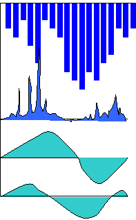
Functionality of the water cycle and its variables (2014)
|
| |
|
This is an anticipated result succeeding the definition of sustainability as functional stability. Among the functions of the water cycle revealed through its variables, adjusting, correcting or buffering are the most prevailing ones, manifested in different shapes of frequency distribution of variables themselves and their dynamic components at different scales. The functional triplet for each variable (the steadying base, the adjusting inter and the disparaging storm components) provides the foundation for understanding that both marginal functions (steadying and destruction) are the tools for adjustment, correction, modification and balancing/buffering. There is no destruction, waste and emptiness in nature, but perpetual fluctuation…
|
|
|
HFA application for erosion
|
| |
|
One of the 2013-year results was a short publication of the HFA application for erosion assessment in the IWA Newsletter of the Modeling and Integrated Assessment Group. It might be interesting for those who receive controversial or inconclusive results in this field.
The second project was related to density assessment of the new fallen snow (SAM_2013) using air temperature, wind speed and humidity. I put the equation for air temperature (°C) and wind speed (m/s) as one table in the Excel file here. The success of humidity was different at different places and in different years. I hope these equations might help in some calculations though, because I checked them in the original daily snow accumulation and melting model for very different conditions of Canada for the periods of 20 years (see here the Toronto station).
On the other sheet of the same Excel file one can find the relationship between snow shrinking and retention capacities, snow density and snow structure (man-made pile and natural cover). Have fun!
|
|
|
“The dynamics of the urban stream contamination”
|
| |
|
Two projects of 2012 clarify some methodical uncertainties of HFA: the universal dynamic structure can be used at any application. The first one, “The dynamics of the urban stream contamination”, which preliminary results were obtained not on the universal SHC and published as a brief report, demonstrates the ability and simplicity of HFA to model daily dynamics of several streams for several contaminants based on limited sampling data and the same universal dynamic structure; it gives possibility to analyze the fate of contamination including the groundwater paths. Some additional and interesting information about surface water – groundwater quality can be found here in my old presentation based on the Fletcher’s Creek project.
The title of the second project, “Erosion: indication in the water level and flow dynamics”, says for itself: HFA of levels and flows at 20 gauges clear points at the station with the bank slide type of erosion.
|
|
|
The hydrological aspects of sustainable development (May 2011)
|
| |
|
The project of 2011 has the same title as the previous one: The hydrological aspects of sustainable development (May 2011). This time it is not just a presentation, but the article (Water Resources Management 2011, WIT Press, p. 125-138) with the more or less complete description of the method, the Harmonized Frequencies Analysis™ (HFA), and its application for the water cycle sustainability assessment within the well developed urbanized (Toronto) watershed of Humber River.
The main feature of the method, the Structural Harmony Chart of Hydrosphere (SHC), has the controlling capacity over the dynamic structures of all involved in its creation variables. The physical roots of this maybe somehow related with the linear function between the yearly or monthly specific usable storages of any lake (βsp) and its corresponding specific area indexes (Ksp). This functional relation (useless so far) was obtained in my thesis (The global regularity of the river flow adjusted by lakes), the extended abstract of which was placed on this site. Possible existence of this relation in the other, more practical, scales (daily, hourly) made me to place the complete material of the thesis (in Russian) on the site for those, who might be interested (modelers). For their convenience, I put the graphs and tables of the Appendix in Excel with formulas.
|
|
|
Water quality and the transport capacity of a stream (2002-2011):
|
| |
|
Water quality and the transport capacity of a stream estimate daily concentrations of the sampled substances using the separated flow as the transport media. I use it every time, when I need to analyze the water quality dynamics. Try this model built on HFA.
|
|
|
The hydrological aspects of sustainable development (November 2009)
|
| |
|
This presentation was the last state of my mind before the definition of sustainability and its inter-scale criteria appeared. Here they are: sustainability is such a scale-invariant self-adjusting dynamic structure of hydrosphere (global water) which provides the functional balance and stability of itself. The most important function of hydrosphere is temperature control, which happens at any scale (life is a self-adjusting solution for that). The condition of this function stability at any spacetime can be numerically expressed as excess of any scale dQb for temperature over the yearly one: dQb (any scale) > dQb (yearly scale).
|
|
|
Numerical and visual interpretation of the anthropogenic impact (June 2008)
|
| |
|
This single, but complex chart gives numerically and visually very certain interpretation of the physical-chemical mechanism of the climate stability. Here are a couple ideas for the community involvement into the water resources management at different scales based on this visualization.
|
|
|
The non-statistical method of the Environmental Assessment (February 2008)
|
| |
|
If you have either qualitative or quantitative data for a watershed or any other territory or object, you can create the SHC based on available data and use it to do the assessment of water quality based on few samples. This is an excellent device for the environmental modeling!
|
|
|
The Environmental ID (October 26, 2007) |
| |
|
The Elasticity or Structural Harmony Chart of Hydrosphere is unique for any location, watershed, and territory… Like our DNA, it has definite order of elements depending on environmental conditions, it has the same structure for quantitative and qualitative characteristics, it looks like X and Y chromosomes…
|
|
|
Elasticity of Hydrosphere (2007) |
| |
|
I do understand how difficult may be for professionals who uses mostly statistical methods to see the non-statistical way for estimation the universal interrelationships between all quantitative and qualitative parameters of hydrosphere. Here is the Excel file of the Fletcher’s Creek data that reveals the phenomenon of the Structural Harmony of the system. Have it!
|
|
|
Fletcher’s Creek Project (2005) |
| |
|
Daily measurements and samples of the creek level, flow, temperature, turbidity and TDS conducted to evaluate the physical concept of its chemical composition.
|
|
|
Separated Flow Approach (2003) |
| |
|
If river flow is the combination of some components, the concentration of any parameter in it will be the weighted average of the parameter's concentrations in each flow component. Discussion and analysis of the Etobicoke Creek's monitoring dataset based on my Russian experience can be found in this article. Description of practical steps of the approach is given in the Fletcher's Creek Project.
|
|
|
SimpleBase Delineation Model TM (2005) |
| |
|
This is my hydrological baby. Everything in my hydrological practice is based on this model (except the waste minimization…).
|
|
|
Groundwater – climate (2004) |
| |
|
This project will be successful in the nearest future: its success in right interpretation of the SimpleBase Delineation Model results, but idea can be already clear understood.
|
|
|
Household waste minimization (2005) |
| |
|
Waste management is the measure of the human society integration into Mother Nature. When our civilization does not leave any waste after itself, we will be harmoniously integrated into the nature, where we are from.
|
|
|
Water balance and regime of Beverly Swamp (1999) |
| |
|
Water balance is the mathematical expression of the overall water concept. Possibility to create monthly water balance based on fragmentary data, to find flooded area, swamp level altitude and outflow.
|
|
|
Water Resources Inventory Model (WRIM) (2000) |
| |
|
Non-standard, practical approach to the overall concept of water based on heavily urbanized watershed of Etobicoke Creek (prototype of watershed approach to ISO 14000).
|
|
|
Equilibrium Water Balance Model (EWBM) (2002) |
| |
|
An original water balance model provides a connection between groundwater and climate, evapotranspiration and runoff, geological condition and hydrological parameters, water budget and balance. There are Etobicoke, Mimico and Spencer watersheds as examples.
|
|
|
Daily Snow accumulation and melting empirical model(SAM)(1999/2003) |
| |
|
SAM gives some imagination about dynamics of the solid phase of water. Based on daily data of air temperature and precipitation from Estonia (Tooma Bog Station)
and Canada (Thunder Bay)
the following parameters of snow cover were estimated on daily basis: snow density (new and aged), water content in snow pack and its depth, duration of snow pack, amount of melted water. |


 These are my hydrological solutions of environmental problems. I consider relationship between Hydrology (water) and Environment (life) very simple: water without environment is just clean water; environment without water does not exist … at list on our planet. Water carry out three pervasive functions: